

@EMODnet 님을 차단했습니다
정말로 이 트윗을 보시겠어요? 트윗을 봐도 @EMODnet 님의 차단을 해제하지 않습니다
-
NEW - The
#data layers on#seafloor#geology show the underlying geology from the Ancient Past to modern Quaternary deposits & geomorphological features. They provide key info for scientists, gov, industry, etc. The map https://bit.ly/2GPSS66
The news http://www.emodnet.eu/node/48180 pic.twitter.com/havLKDue6E
https://bit.ly/2GPSS66
The news http://www.emodnet.eu/node/48180 pic.twitter.com/havLKDue6E

 감사합니다. 보내주신 피드백은 타임라인을 개선하는 데 사용됩니다. 취소취소
 -
NEW on the
#EMODnet#Geology portal! Discover 12 new GIS layers concerning#earthquakes,#submarinelandslides,#volcanoes,#tsunamis,#fluidemissions &#Quaternarytectonics. Access the maps: https://bit.ly/2vk7MuO Read the news: http://www.emodnet.eu/node/48178 pic.twitter.com/Z2PYh8DPLI 감사합니다. 보내주신 피드백은 타임라인을 개선하는 데 사용됩니다. 취소취소
 -
EMODnet 님이 리트윗했습니다
#SavetheDate:#opendata#hackathon with@OpenSeaLab 4-6th September 2019!
-Using
4-6th September 2019!
-Using @CMEMS_EU,@EMODnet &@ICES_ASC resources! -Sign up below!#BlueGrowth#Sustainable#Ocean@EU_MARE@EU_ENV@WEkEO_dias@CopernicusEUhttps://twitter.com/MEDIN_marine/status/1121330565838462976 … 감사합니다. 보내주신 피드백은 타임라인을 개선하는 데 사용됩니다. 취소취소
 -
Join us for the second
#EMODnet@OpenSeaLab#hackathon to develop novel#marine &#maritime applications using@EMODnet,@ICES_ASC &@CMEMS_EU's wealth of#marinedata & services. Kick-off event on 24 May. Register now! More info http://www.opensealab.eu pic.twitter.com/96J9lFC76D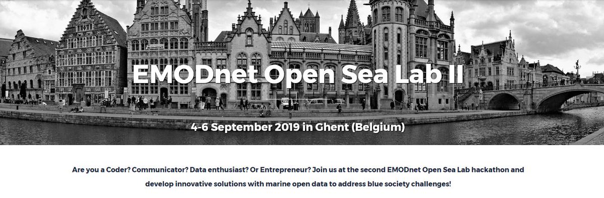 감사합니다. 보내주신 피드백은 타임라인을 개선하는 데 사용됩니다. 취소취소
 -
EMODnet 님이 리트윗했습니다
New
#openaccess paper: Results of an@EMODnet Geology case study demonstrates how legacy seabed sampling data can be used to produce quantitative maps of seabed sediment composition and estimates of map accuracy. https://www.mdpi.com/2076-3263/9/4/182 …@p_mitchell_2015@CefasGovUK@NGUmarinpic.twitter.com/G1xEvcP2xk 감사합니다. 보내주신 피드백은 타임라인을 개선하는 데 사용됩니다. 취소취소
 -
EMODnet 님이 리트윗했습니다
Willi Petersen
@HZG_de, Co-chair of FerryBox#EuroGOOSTaskTeam, opening the 2019 workshop at the Acquario di Genova - state of play and forward look with regards to this efficient#oceanobserving technology from#EuroGOOS,@Jerico_NEXT,@ICOS_RI ,@EMODnet,@CMEMS_EUpic.twitter.com/iqt1M0F3Wo

 감사합니다. 보내주신 피드백은 타임라인을 개선하는 데 사용됩니다. 취소취소
 -
We are ready to start the FerryBox workshop that was jointly organized by the
@EuroGOOS Ferrybox Task Team,@Jerico_NEXT,@ICOS_RI &#EMODnet! More info : https://bit.ly/2PtoZuO pic.twitter.com/0ZcdFR35ia 감사합니다. 보내주신 피드백은 타임라인을 개선하는 데 사용됩니다. 취소취소
 -
Another interesting dataset has been released today by
#EMODnet#Geology! Check out the harmonised multiscale#maps of the#seabed#substrate https://bit.ly/2W364d0
Read the news http://www.emodnet.eu/node/48176 pic.twitter.com/bYaCUwiVbT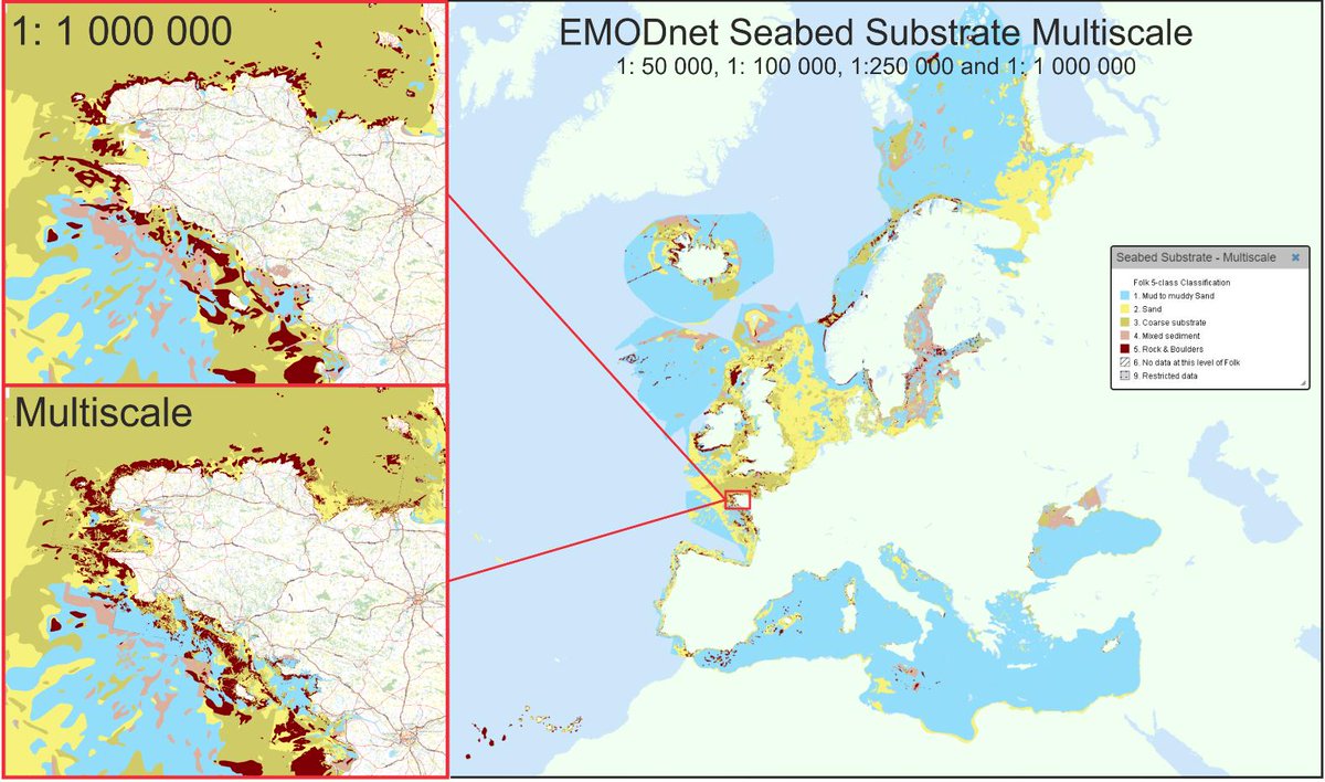 감사합니다. 보내주신 피드백은 타임라인을 개선하는 데 사용됩니다. 취소취소
 -
EMODnet 님이 리트윗했습니다
The
#EU & the#Smurfs have signed a cooperation agreement to clean up beaches across the world & encourage people to take care of#OurOcean &#seas! Read more
#BluePlanet#OceanEU#SDG14#EUBeachCleanUp#MarineLitter
@EU_MARE@EuropeAtlasSeashttps://ec.smh.re/lWL감사합니다. 보내주신 피드백은 타임라인을 개선하는 데 사용됩니다. 취소취소 -
EMODnet 님이 리트윗했습니다
Great research and teaching tool for our island that has a huge glacial footprint on land and at seahttps://twitter.com/EMODnet/status/1119158018556305408 …
 NEW - For the first time, information on the character & evolution of
#submerged#landscape features have been collated & harmonised across European#Seas. Well done#EMODnet#Geology! Access the map https://bit.ly/2XpujCo
Read the news http://www.emodnet.eu/node/48173 pic.twitter.com/Hzb2xAV9zZ감사합니다. 보내주신 피드백은 타임라인을 개선하는 데 사용됩니다. 취소취소
Access the map https://bit.ly/2XpujCo
Read the news http://www.emodnet.eu/node/48173 pic.twitter.com/Hzb2xAV9zZ감사합니다. 보내주신 피드백은 타임라인을 개선하는 데 사용됩니다. 취소취소 -
EMODnet 님이 리트윗했습니다
Have a look at the
@EMODnet map ! New information on#submerged#landscape features are available ! The map is here https://bit.ly/2XpujCo https://twitter.com/EMODnet/status/1119158018556305408 …
NEW - For the first time, information on the character & evolution of#submerged#landscape features have been collated & harmonised across European#Seas. Well done#EMODnet#Geology!
Access the map https://bit.ly/2XpujCo
Read the news http://www.emodnet.eu/node/48173 pic.twitter.com/Hzb2xAV9zZ감사합니다. 보내주신 피드백은 타임라인을 개선하는 데 사용됩니다. 취소취소 -
NEW - For the first time, information on the character & evolution of
#submerged#landscape features have been collated & harmonised across European#Seas. Well done#EMODnet#Geology!
Access the map https://bit.ly/2XpujCo
Read the news http://www.emodnet.eu/node/48173 pic.twitter.com/Hzb2xAV9zZ
감사합니다. 보내주신 피드백은 타임라인을 개선하는 데 사용됩니다. 취소취소 -
EMODnet 님이 리트윗했습니다
A new data release is always exciting. Scientists from the Marine & Coastal Unit in Geological Survey Ireland
@Dept_CCAE were Work Package leaders in this@EMODnet (European Marine Observation and Data network) project on European seabed minerals. https://www.gsi.ie/en-ie/events-and-news/news/Pages/EMODnet-Geology-Minerals-Dataset.aspx …pic.twitter.com/Jo9r693IwM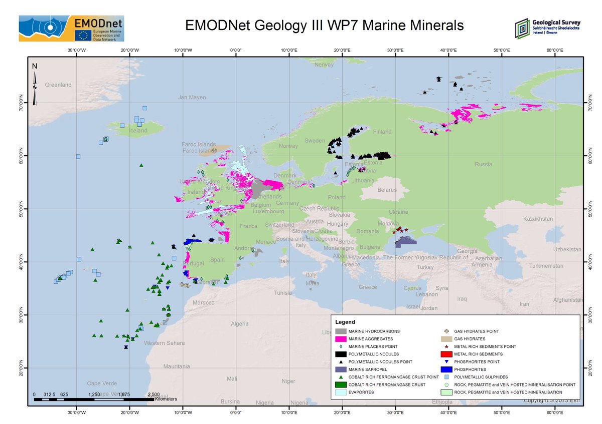 감사합니다. 보내주신 피드백은 타임라인을 개선하는 데 사용됩니다. 취소취소
 -
EMODnet 님이 리트윗했습니다
A map which shows the rate at which European coastlines are changing has been released by
@EMODnet with the help of an@EHU_Geo academic. Read the full story here: https://www.edgehill.ac.uk/geography/news/2019/04/10/new-european-map-shows-rate-of-shoreline-change/ …pic.twitter.com/jrDEMhx2Bl 감사합니다. 보내주신 피드백은 타임라인을 개선하는 데 사용됩니다. 취소취소
 -
EMODnet 님이 리트윗했습니다
Proud to have worked with
@GeolSurvIE and all@EMODnet#Geology partners on creating a map of recorded and available#minerals, raw#materials and#hydrocarbons in European#sea regions and subregions as defined by#MSFD@followtheboats#SustainableDevelopmenthttps://twitter.com/EMODnet/status/1118072381879332864 … NEW on the
#EMODnet#Geology portal! The
The #marine#minerals datasets include 12 types of minerals known to accumulate in seas surrounding#Europe & have relevance for many uses. Access the mapshttps://bit.ly/2UgtZUB
Read the news http://www.emodnet.eu/node/48168 pic.twitter.com/a5Hj7uwMz8감사합니다. 보내주신 피드백은 타임라인을 개선하는 데 사용됩니다. 취소취소 -
NEW on the
#EMODnet#Geology portal!
The #marine#minerals datasets include 12 types of minerals known to accumulate in seas surrounding#Europe & have relevance for many uses. Access the mapshttps://bit.ly/2UgtZUB
Read the news http://www.emodnet.eu/node/48168 pic.twitter.com/a5Hj7uwMz8
감사합니다. 보내주신 피드백은 타임라인을 개선하는 데 사용됩니다. 취소취소 -
EMODnet 님이 리트윗했습니다
Powerful for sea exploitation and a lot of issues such as
#maritime safety. Great crossing with well managed information.https://twitter.com/EMODnet/status/1105046884752723969 … 감사합니다. 보내주신 피드백은 타임라인을 개선하는 데 사용됩니다. 취소취소
 -
Excellent overview of the new
#EMODnet vessel density maps by Eurofish Magazine! https://bit.ly/2UH3gpr (page 14)#OpenData#BlueGrowth#BlueEconomy#shipping#fishing#Ocean#Maritime#MSP#OceanEnergypic.twitter.com/DT3Av8flSm 감사합니다. 보내주신 피드백은 타임라인을 개선하는 데 사용됩니다. 취소취소
 -
EMODnet 님이 리트윗했습니다
Essential Biological Data Products - A Showcase for the European Atlas of Marine Life. 15th May 2019, Lisbon. Register here for this
@EMODnet event - https://www.eventbrite.co.uk/e/a-showcase-for-the-european-atlas-of-marine-life-tickets-55404526430 …#opendata#FAIRdata감사합니다. 보내주신 피드백은 타임라인을 개선하는 데 사용됩니다. 취소취소 -
EMODnet 님이 리트윗했습니다
Using
#EarthObservation &#MarineData to tackle#ClimateChange. Hundred institutions contribute in partnership to@EMODnet providing#OpenData on#aquaculture,#ports,#hydrocarbon,#shipping,#marinelitter & more
#OurOcean#SatelliteData#EMFF#BlueEconomy#Balkan#BlackSeapic.twitter.com/ijPallwIt2 이 스레드 보기감사합니다. 보내주신 피드백은 타임라인을 개선하는 데 사용됩니다. 취소취소

 EASME
EASME


로딩하는데 시간이 지연되고 있습니다.
트위터의 트래픽이 폭주했거나 일시적인 문제가 발생했을 수 있습니다. 다시 시도하거나 트위터 상태 페이지를 방문하여 자세한 내용을 확인해 보세요.